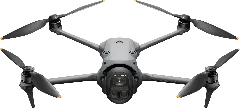
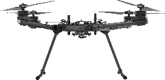
Freefly Alta X Gen2 vs DJI Mavic 4 Pro
Flight Time vs Price
Megapixels vs Price
Key Differences
- Price (US)$39,650 vs $2,899
- Weight10,860 g vs 1,063 g
- Max Flight Time50 min vs 51 min
- Max Flight Distance20 km vs 41 km
- Max Speed26 m/s vs 25 m/s
- Wind Resistance10 m/s vs 12 m/s
- Megapixels (RED Komodo 6K)19.9 MP vs 100 MP
- Megapixels (LR1 (Sony ILX-LR1))61 MP vs 48 MP
- Megapixels (Tele Camera)N/A vs 50 MP
User Reviews
Identity8
Manufacturer
DJI
Freefly
Rating
Release Date
May 13, 2025
Feb 5, 2026
Availability
Available
Available
EU Drone Class
C2
None
US Procurement
FASC Prohibited
—
Platform Type
Multirotor
Multirotor
Pricing2
Price (EU) (€)
€2,169
€36,478
Price (US) ($)
$2,899
$39,650
Links2
Physical5
Weight (g)
1,063 g
10,860 g
Max Takeoff Weight (g)
1,063 g
34,860 g
Folded Dimensions (mm)
257.6 × 124.8 × 103.4 mm
877 × 877 × 387 mm
IP Rating
None
IP43
Operating Temperature (°C)
-10°C to 40°C
-20°C to 50°C
Flight8
Max Flight Time (min)
51 min
50 min
Max Speed (m/s)
25 m/s
26 m/s
Max Speed (EU) (m/s)
25 m/s
—
Max Ascent Speed (m/s)
10 m/s
4 m/s
Max Descent Speed (m/s)
10 m/s
4 m/s
Max Flight Distance (km)
41 km
20 km
Max Altitude (m)
6,000 m
5,000 m
Wind Resistance (m/s)
12 m/s
10 m/s
Payload1
Camera3
Camera 1
Hasselblad Camera
RED Komodo 6K
Sensor Size
4/3"
Super 35
Pixel Binning
Quad Bayer
—
Megapixels (MP)
100 MP
19.9 MP
Focal Length
28mm
24-70mm
Aperture
f/2.0-f/11
f/2.8
Zoom
2.5x Digital
—
Mechanical Shutter
✗ No
✗ No
ISO Range
100-3200100-12800
250-12800 (Native)
Shutter Speed
1/16000-16s1/8000-8s
1/8000-1/24s (Global Shutter)
+1Stabilization Type
—
Mechanical Gimbal
Max Photo Resolution
12288x8192
6144x3240
Image Formats
JPEGDNG (RAW)
RAW (Proprietary)
AEB
3 Frames5 Frames7 Frames
+1—
AEB EV Bias
0.7 EV
—
Panorama Modes
Sphere180°Wide AngleVerticalUser-Defined
+3—
Panorama Formats
JPEG
—
Video Resolutions
6K/60fps4K/120fps
6K/40fps5K/48fps4K/60fps2K/120fps
+2Video Codec
H.264 (AVC)H.265 (HEVC)
+1ProRes 422 HQProRes 422
+1Video Formats
MP4
MOV
Color Profiles
NormalD-LogD-Log MHLG
+2Normal
Camera 2
Medium Tele Camera
LR1 (Sony ILX-LR1)
Camera 3
Tele Camera
Gimbal1
Gimbal2
Gimbal 1
Camera Gimbal
Freefly MoVI Pro
Stabilization Axes
3-Axis
3-Axis
Tilt Range (°)
-90° to 70°
-90° to 165°
Pan Range (°)
-22° to 22°
-360° to 360°
Roll Range (°)
-40° to 400°
-60° to 60°
Gimbal 2
LR1 Gimbal
Navigation10
GNSS
GPSGalileoBeiDou
GPSGLONASSBeiDouGalileo
+2Hover Accuracy
Vert: ±0.1m (Vision), ±0.5m (GNSS); Horiz: ±0.3m (Vision), ±0.5m (GNSS)
—
RTK
No
Add-on
RTK Horizontal Accuracy
—
1 cm + 1 ppm (RMS)
RTK Vertical Accuracy
—
1 cm + 1 ppm (RMS)
Recovery Mode
—
—
Obstacle Sensors
ForwardBackwardLateralUpwardDownward
+3—
Obstacle Avoidance
Active (Avoidance)
None
Sensing Technology
Vision (Binocular)LiDARInfrared (ToF)
+1—
Sensing Technology (Add-on)
—
—
Transmission5
Transmission Protocol
OcuSync 4+
Herelink 1.1
Max Range (CE) (km)
15 km
12 km
Max Range (FCC) (km)
30 km
20 km
Live View Quality
1080p/30fps1080p/60fps
+11080p/60fps720p/30fps
+1Cellular
✗ No
✓ Yes
App4
Flight App
DJI Fly
Auterion Suite
Supported OS
AndroidiOS
Android
Resume from Waypoint
✗ No
—
Mission Types
Waypoint
Waypoint
Features13
Internal Storage (GB)
42 GB
—
Max MicroSD (GB)
1,024 GB
—
ActiveTrack
✓ Yes
✗ No
Hyperlapse
✓ Yes
—
Night Scene
✓ Yes
—
NIR Light
✗ No
—
Laser Rangefinder
✗ No
—
Laser Rangefinder Range (m)
—
—
Remote ID
Built-in
Built-in
ADS-B Receiver
✓ Yes
✗ No
Data Encryption
✗ No
✓ Yes
Expansion Port
✗ No
✓ Yes
SDK Support
✗ No
✓ Yes
Mapping3
Waypoints
✓ Yes
✓ Yes
Terrain Follow
✗ No
✓ Yes
Raw GNSS Logging
✗ No
✓ Yes
Cargo3
Delivery Mode
—
—
Max Range (Loaded) (km)
—
—
Max Flight Time (Loaded) (min)
—
—
Accessories4
Battery1
Propeller1
Remote Controller2
Charger1