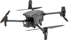
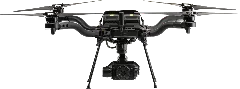
Freefly Astro Max vs DJI Matrice 30T
Flight Time vs Price
Megapixels vs Price
Key Differences
- Price (US)$22,995 vs $9,999
- Weight3,523 g vs 3,770 g
- Max Flight Time43 min vs 41 min
- Max Flight Distance20 km vs N/A
- Max Speed15 m/s vs 23 m/s
- Wind Resistance10 m/s vs 12 m/s
- Megapixels61 MP vs 12 MP
- Sensor SizeFull Frame vs 1/2"
- Obstacle AvoidanceNone vs Active (Avoidance)
No reviews yet — be the first!
Identity7
Manufacturer
DJI
Freefly
Rating
Release Date
Oct 13, 2022
Feb 20, 2025
Availability
Available
Available
EU Drone Class
C2
None
Platform Type
Multirotor
Multirotor
Pricing2
Price (EU) (€)
€10,953
€21,155
Price (US) ($)
$9,999
$22,995
Links2
Physical5
Weight (g)
3,770 g
3,523 g
Max Takeoff Weight (g)
4,069 g
8,700 g
Folded Dimensions (mm)
—
508 × 508 × 178 mm
IP Rating
IP55
IP43
Operating Temperature (°C)
-20°C to 50°C
-20°C to 50°C
Flight8
Max Flight Time (min)
41 min
43 min
Max Speed (m/s)
23 m/s
15 m/s
Max Speed (EU) (m/s)
—
—
Max Ascent Speed (m/s)
6 m/s
4 m/s
Max Descent Speed (m/s)
5 m/s
3 m/s
Max Flight Distance (km)
—
20 km
Max Altitude (m)
7,000 m
4,572 m
Wind Resistance (m/s)
12 m/s
10 m/s
Payload1
Camera3
Camera 1
Wide Camera
LR1 (Sony ILX-LR1)
Sensor Size
1/2"
Full Frame
Megapixels (MP)
12 MP
61 MP
Focal Length
24mm
24mm35mm50mm75mm
+1Aperture
f/2.8
f/3.5f/2.8f/1.8
Zoom
—
—
Mechanical Shutter
✗ No
✓ Yes
ISO Range
100-25600 (Photo)100-25600 (Video)
+1100-32000 (Normal)50-102400 (Extended)
+1Shutter Speed
1/8000-8s
1/4000-30s (Mechanical)1/8000-30s (Electronic)
+1Stabilization Type
—
Mechanical Gimbal
Max Photo Resolution
4000x3000
9504x6336
Image Formats
JPEG
JPEGRAW (Proprietary)HEIF
+1AEB
—
—
AEB EV Bias
—
—
Panorama Modes
—
—
Panorama Formats
—
—
Video Resolutions
4K/30fps
4K/60fps1080p/120fps
Video Codec
H.264 (AVC)H.265 (HEVC)
+1H.265 (HEVC)H.264 (AVC)
+1Video Formats
MP4
MP4
Color Profiles
—
NormalHLGS-Log3S-Cinetone
+1Camera 2
Zoom Camera
Camera 3
Thermal Camera
Gimbal1
Gimbal1
Gimbal 1
Camera Gimbal
LR1 Gimbal
Stabilization Axes
3-Axis
3-Axis
Tilt Range (°)
-120° to 45°
-90° to 30°
Pan Range (°)
-90° to 90°
—
Roll Range (°)
—
—
Navigation9
GNSS
GPSGalileoBeiDouGLONASS
+1GPSGLONASSBeiDouGalileo
+2Hover Accuracy
Vert: ±0.1m (Vision), ±0.5m (GNSS), ±0.1m (RTK); Horiz: ±0.3m (Vision), ±1.5m (GNSS), ±0.1m (RTK)
—
RTK
Yes
Add-on
RTK Horizontal Accuracy
1 cm + 1 ppm (RMS)
1 cm + 1 ppm (RMS)
RTK Vertical Accuracy
1.5 cm + 1 ppm (RMS)
1 cm + 1 ppm (RMS)
Obstacle Sensors
ForwardBackwardLateralUpwardDownward
+3—
Obstacle Avoidance
Active (Avoidance)
None
Sensing Technology
Vision (Binocular)Infrared (ToF)
+1—
Sensing Technology (Add-on)
—
—
Transmission5
Transmission Protocol
OcuSync 3E
Herelink 1.1
Max Range (CE) (km)
8 km
12 km
Max Range (FCC) (km)
15 km
20 km
Live View Quality
1080p/30fps
1080p/60fps720p/30fps
+1Cellular
✗ No
✓ Yes
App4
Flight App
DJI Pilot 2
Auterion Suite
Supported OS
Android
Android
Resume from Waypoint
✓ Yes
—
Mission Types
—
Waypoint
Features12
Internal Storage (GB)
—
—
Max MicroSD (GB)
128 GB
—
ActiveTrack
✗ No
✗ No
Hyperlapse
✗ No
—
Night Scene
✗ No
—
NIR Light
✗ No
—
Laser Rangefinder
✓ Yes
—
Laser Rangefinder Range (m)
1,200 m
—
ADS-B Receiver
✓ Yes
✗ No
Data Encryption
✓ Yes
✓ Yes
Expansion Port
✓ Yes
✓ Yes
SDK Support
✓ Yes
✓ Yes
Mapping3
Waypoints
✓ Yes
✓ Yes
Terrain Follow
✓ Yes
✓ Yes
Raw GNSS Logging
—
✓ Yes
Cargo3
Delivery Mode
—
—
Max Range (Loaded) (km)
—
—
Max Flight Time (Loaded) (min)
—
—
Accessories4
Battery1
Propeller1
Remote Controller1
Charger1